
Auyuittuq National Park of Canada Draft Management Plan, 2026
Auyuittuq National Park
Publication information
© His Majesty the King in Right of Canada, represented by the Minister of Environment, Climate Change, and Nature, 2026.
Auyuittuq National Park of Canada Draft Management Plan, 2026.
ᐅᑯᐊ ᓴᖅᑭᖅᑎᑕᐅᔪᑦ ᐊᑐᐃᓐᓇᐅᒻᒥᔪᑦ ᐃᓄᒃᑎᑐᑦ:
ᐊᐅᔪᐃᑦᑐᖅ ᑲᓇᑕᒥ ᒥᕐᖑᐃᓯᕐᕕᒃ ᐊᐅᓚᑦᑎᓂᕐᒧᑦ ᐸᕐᓇᐅᑎᑦ ᑎᑎᕋᕐᑕᐅᒋᐊᙵᕐᑐᑦ ᑭᒃᑯᑐᐃᓐᓇᕐᓄᑦ ᑐᑭᓯᖃᑎᒌᒍᑎᑦᓴᑦ ᐅᓂᒃᑳᖑᔭᕆᐊᓖᑦ 2026
Cette publication est aussi disponible en français :
Ébauche du plan directeur du Parc national du Canada Auyuittuq, 2026
Note to readers
Through generations of travel on the lands, waters, and ice of Auyuittuq National Park, Inuit have developed placenames that reflect their experiences and observations. This plan features Inuit placenames in the park that were documented through the Inuit Placenames Project, which was completed in 2018 and involved collaborative work by Elders, the Inuit Knowledge Working Groups of Pangnirtung and Qikiqtarjuaq, Inuit Heritage Trust, and Parks Canada.
For more information about the management plan or about Auyuittuq National Park of Canada:
Auyuittuq National Park
PO Box 353
Pangnirtung, NU X0A0R0
Canada
1.0 Introduction
Auyuittuq National Park of Canada, a special place within Inuit Nunangat (Inuit homeland), is located in the Qikiqtaaluk region of Nunavut (Map 1), where Inuit and their ancestors have been stewards of the lands, ice, and waters since time immemorial. Joint management by Parks Canada and Inuit is centered around a vision of governance that promotes continued Inuit stewardship, honours shared commitments, advances reconciliation, and supports implementation of the Declaration on the Rights of Indigenous Peoples Act.
Parks Canada’s mandate is to protect and present national heritage places for the benefit and enjoyment of current and future generations. The Canada National Parks Act requires that Parks Canada prepare a management plan for each national park that it has a role in administering. For Auyuittuq National Park, the Inuit Impact and Benefit Agreement for Auyuittuq, Quttinirpaaq, and Sirmilik National Parks (Baffin IIBA) guides the management planning process and ensures Inuit are involved in management decision-making for the park.
The Auyuittuq National Park of Canada Management Plan supports Parks Canada’s accountability to Canadians, providing clear direction for long-term stewardship and outlining how management of the national park delivers measurable results. This is the second management plan for Auyuittuq National Park, following an initial plan implemented in 2010. The plan acts as a roadmap, outlining priorities for the next ten years. It presents the park’s context, provides a vision, defines key strategies, sets measurable objectives, and outlines zoning for the park. A strategic environmental assessment, summarized in the plan, reviews anticipated outcomes from implementing the plan together with other activities and changes that may impact the park.
Auyuittuq National Park, like other national heritage places in Canada, is facing significant environmental challenges. Climate change is reshaping ecosystems, affecting cultural traditions and cultural heritage on the landscape, threatening infrastructure and resources, and changing how people experience heritage places. To adjust to these challenges and build resiliency, Parks Canada takes a proactive and flexible approach. For Auyuittuq National Park, this includes regularly assessing conditions and trends, identifying where action is needed, and working with Inuit partners and stakeholders to make and communicate management decisions. Parks Canada remains deeply committed to ecosystem conservation, cultural heritage, and providing meaningful experiences for current and future generations, and will do so in a sustainable manner that recognizes operational, financial, and ecological limitations.
The Auyuittuq National Park of Canada Management Plan is a tool for decision-makers to manage activities taking place within the park and to guide more detailed planning and reporting over the next decade. The plan serves as a focus for ongoing engagement, community involvement in the enjoyment and protection of the park and, where appropriate, consultation on the management of Auyuittuq National Park in years to come.
Map 1: Regional setting of Auyuittuq National Park
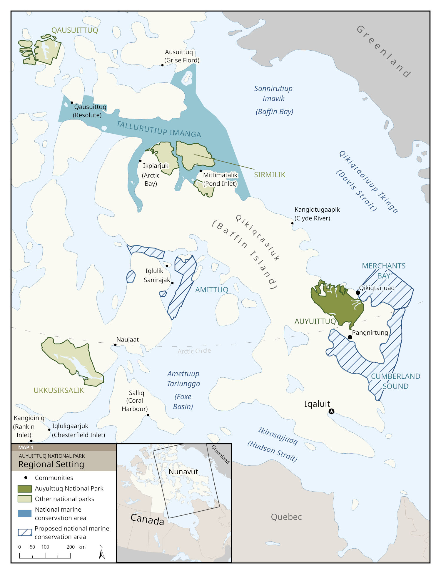
Map 1: Regional setting of Auyuittuq National Park — Text description
This map shows the eastern Canadian Arctic, focusing on Qikiqtaaluk (Baffin Island) in the territory of Nunavut. It includes protected areas administered by Parks Canada, communities, islands, and waterways. A small inset at the bottom locates Nunavut within northeastern Canada.
Main area and orientation: The map is oriented north-up and Qikiqtaaluk occupies the center. To the east, across a wide body of water labeled Qikiqtaaluup Ikinga (Davis Strait), lies Greenland. To the south is Ikirasajjuaq (Hudson Strait), with northern Quebec beyond it.
National parks
- Auyuittuq National Park is shown in dark green on the southeastern coast of Baffin Island. It stretches between the coast near Cumberland Sound to the coast of Qikiqtaaluup Ikinga
- Other national parks in the region are shown in lighter green:
- Sirmilik National Park near Pond Inlet and Arctic Bay
- Qausuittuq National Park far to the northwest, beyond Resolute
- Ukkusiksalik National Park on the mainland south of Naujaat
National marine conservation areas
- Tallurutiup Imanga National Marine Conservation Area, shown in medium blue, lies north of Qikiqtaaluk between Resolute and Pond Inlet
- Dark blue hatched areas indicate proposed marine conservation areas around the southern and eastern coasts of Qikiqtaaluk, including parts of Cumberland Sound and waters near Amettuup Tariungga (Foxe Basin)
Communities labeled on Qikiqtaaluk
- Iqaluit in the south (territorial capital)
- Pangnirtung to the south of Auyuittuq National Park and northeast of Cumberland Sound
- Qikiqtarjuaq to the east of Auyuittuq National Park, on the eastern coast of Qikiqtaaluk
- Clyde River farther north along the east coast
- Pond Inlet and Arctic Bay in the far north
Other geographic features
- The Arctic Circle is drawn as a dashed line crossing the southern part of Baffin Island, along the south end of Auyuittuq National Park
- Major surrounding water bodies are labeled, including Sannirutiup Imavik (Baffin Bay) in the northeast and Tallurutiup Imanga (Lancaster Sound) in the northwest
Legend (explained in words)
- Dark green: Auyuittuq National Park
- Light green: Other national parks
- Solid medium blue: Tallurutiup Imanga National Marine Conservation Area
- Dark blue hatching: Proposed national marine conservation areas
- Black dots: Communities
A scale bar (0–200 km) appears at the bottom.
2.0 Significance of Auyuittuq National Park
The fifth-largest national park in Canada, Auyuittuq includes 19,089 km2 of lands, ice, and waters (Map 2). Qikiqtarjuaq and Pangnirtung are its two adjacent communities. Inuit selected the name Auyuittuq, Inuktitut for “land that never melts,” for this Arctic park where ice, in many forms, shapes the environment and how people interact with it.
Auyuittuq is culturally significant to Inuit as a home, for travel routes, for harvesting food, and for spiritual places. People have inhabited what is now the park area for over 3,500 years, starting when Paleo-Inuit arrived from the western Arctic. Archaeological sites show that the Tuniit (Dorset) peoples were in the region around 2,800 years ago, followed by Thule Inuit around 700 years ago. Oral histories describe extensive travel through the area by Inuit and earlier hunting peoples, with many places that Inuit families visit today having been in continuous use for generations. Akshayuk Pass, an important route through the park, has been a conduit for regional trade in recent decades, was used to transport people from surrounding areas to the former St. Luke’s Mission Hospital in Pangnirtung for care, and continues to serve as a link between communities. Inuit Qaujimajatuqangit, traditional placenames, and namesakes foster enduring connections between Inuit, their ancestors, and Auyuittuq National Park.
Through advocacy and leadership, the national organization Inuit Tapiriit Kanatami was instrumental in achieving changes to the Canada National Parks Act that resulted in Auyuittuq’s establishment as Nunavut’s first national park reserve in 1976. The new park reserve system allowed local Inuit to continue hunting, fishing, and trapping within Auyuittuq, and put the establishment of a full national park on hold until after the settlement of the Nunavut Agreement. Inuit staff and community members have continued to share knowledge and guidance essential to effective park operations in subsequent years, including through a formal cooperative management system that has been in place since 2001. Inuit remain integral to the park’s living cultural heritage and its ecosystems.
Within the National Parks System Plan, Auyuittuq represents the Northern Davis Natural Region, an environment with mountains, glaciers, fiords, and abundant marine wildlife. Highlands have extensive glaciers as well as some of the tallest and most unique peaks in the Canadian Shield, like the sheer face of Qaiqsualuk (Thor Peak) and barrel-like Qattaujannguaq (Mt. Asgard). Tundra lowlands and waterways provide habitat for several species important to Inuit, including caribou, Arctic char, birds, Arctic hares, Arctic wolves, and foxes. Fisheries and Oceans Canada considers Auyuittuq’s fiords as part of the Baffin Island Coastline Ecologically and Biologically Significant Area. These rich marine ecosystems are home to polar bears, seabirds, bowhead whales, corals, narwhal, fish, seals, walrus, and belugas. The marine environment immediately adjacent to the park boundary is part of the proposed Cumberland Sound and Merchants Bay National Marine Conservation Area.
Visitors come from across Canada and around the world to experience Auyuittuq. The spectacular Akshayuk Pass route has drawn hikers, skiers, and climbers for decades. The park fosters opportunities for Canadians to learn from Inuit about their heritage and culture, while virtual outreach helps to share Auyuittuq National Park with the world.
Map 2: Local setting of Auyuittuq National Park
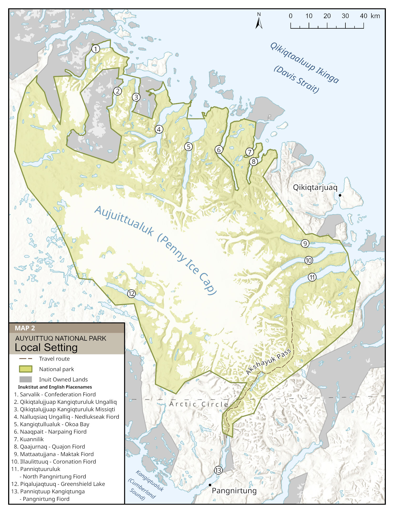
Map 2: Local setting of Auyuittuq National Park — Text description
This map shows Auyuittuq National Park between Cumberland Sound in the southwest and Qikiqtaaluup Ikinga (Davis Strait) in the northeast. The park area is shown in light green and includes shaded terrain, glaciers, and waterways.
The community of Qikiqtarjuaq is about 25 km east of the park boundary and Pangnirtung is about 25 km to the south. A dashed brown line shows a 100 km long travel route through Akshayuk Pass running north-south on the southeastern side of the park. Parcels of Inuit Owned Lands around the park are shaded in grey. A scale bar (0-40 km) appears at the top right.
The map has a north-up orientation. The legend includes a numbered list of Inuktitut and official placenames for waterways in the park. Each numbered placename corresponds to a location on the map.
Northern boundary of the park
- Sarvalik – Confederation Fiord
- Qikiqtalujjuap Kangiqturuluk Ungalliq
- Qikiqtalujjuaq Kangiqturuluk Missiqti
- Nalluqsiaq Ungalliq – Nedlukseak Fiord
- Kangiqtullualuk – Okoa Bay
- Naaqpait – Narpaing Fiord
- Kuannilik
- Qaajurnaq – Quajon Fiord
Western boundary of the park
- Mattaatujjana – Maktak Fiord
- Illaulittuuq – Coronation Fiord
- Panniqtuuruluk – North Pangnirtung Fiord
Eastern boundary of the park
- Piqalujaqtuuq – Greenshield Lake Southern boundary of the park
- Panniqtuup Kangiqtunga – Pangnirtung Fiord
Legend (explained in words):
- Dashed brown line: travel route
- Green: national park
- Grey: Inuit Owned Land
3.0 Planning context
Legal and governance framework
The Nunavut Agreement prevails where any legal inconsistencies or conflicts arise in the management of Auyuittuq National Park, which is legislated through the Canada National Parks Act. In 1999, the Qikiqtani Inuit Association and the Government of Canada signed an Inuit Impact and Benefit Agreement for Auyuittuq, Quttinirpaaq and Sirmilik National Parks (Baffin IIBA), which sets out a governance system for cooperative management. A Joint Park Planning and Management Committee, comprised of an equal number of members appointed by the Qikiqtani Inuit Association and by the Minister responsible for Parks Canada, meets regularly and advises Parks Canada on management matters. The Baffin IIBA also provides opportunities for Inuit in the adjacent communities of Qikiqtarjuaq and Pangnirtung to realize economic benefits relating to the park. These benefits include, among others, promoting and contracting Inuit-owned businesses as well as hiring and supporting career development of Inuit staff members.
Within the life of this plan, a few key agreements are expected to affect the management context for Auyuittuq National Park. Through the Qikiqtani Project Finance for Permanence, the Qikiqtani Inuit Association put forward an Inuit-led approach for regional conservation in the 2025 SINAA Agreement (whose name reflects the Inuktitut term for the floe edge). Parks Canada is committed to working with the Qikiqtani Inuit Association to implement aspects of the SINAA Agreement as applicable. Renegotiation of the Baffin IIBA is also anticipated to begin in the coming years. Although no Parks Canada lands will be transferred through the 2024 Nunavut Lands and Waters Devolution Agreement, Crown lands adjacent to the park boundary will undergo a jurisdictional change. The devolution agreement directs the transfer of public lands, related resources, and water rights from the Government of Canada to the Government of Nunavut by April 1, 2027. It excludes Inuit-owned land, which continues to be administered by the Qikiqtani Inuit Association as the Regional Inuit Association in the Qikiqtaaluk.
Inuit Qaujimajatuqangit and Inuit culture
Inuit Qaujimajatuqangit means the traditional, current and evolving body of Inuit values, beliefs, experience, perceptions and knowledge regarding the environment, including land, water, wildlife and people, to the extent that people are part of the environment. It is knowledge that has sustained the past and that is to be used today to ensure an enduring future. In Auyuittuq National Park, Inuit Qaujimajatuqangit represents a fundamental way of understanding the lands, waters, ice, wildlife, ecosystems, history, and places of cultural significance based on the lived experiences of Inuit over generations. Inuit continue to practice their culture and rights in and around the park, with Inuit societal values and Inuktitut as important aspects of everyday life. Inuit Knowledge Working Groups in both Qikiqtarjuaq and Pangnirtung contribute their knowledge and expertise through various activities, including a traditional placenames map for the park that was completed in 2018. Work led by Inuit staff and involving the Joint Park Planning and Management Committee also helps incorporate Inuit Qaujimajatuqangit principles and approaches. This plan strengthens Parks Canada’s commitment to realize Inuit Qaujimajatuqangit throughout park management and operations.
Community histories
Past government policies have profoundly affected Inuit in ways that continue to be felt today. Many Inuit in the Qikiqtaaluk region resided in nunaliit, small communities with a leader, until the 1950s. The Qikiqtani Truth Commission calls the decade that followed nunalinnguqtitauliqtilluta, “the time when we were actively (by outside force) formed into communities”. Government authorities coerced Inuit to settle in Pangnirtung and Qikiqtarjuaq by promising schooling, healthcare, housing, employment, and financial aid. At Qivittuuq (Kivitoo), buildings and possessions were bulldozed during a forced relocation in 1963, and yet more Inuit were made to relocate from Paallavvik (Padloping Island) to Qikiqtarjuaq in 1968. Police shot many sled dogs during this period, taking away Inuit families’ means of travel and harvesting. Most Inuit lived in communities by the 1970s and felt they had been misled: quality of life had not improved and services remained insufficient. Canadian authorities designed and implemented these policies without proper consultation, explanation, or enough funding to sustain programs. The Qikiqtani Truth Commission’s final report, incorporating many survivor testimonies, describes these challenging early years in Qikiqtarjuaq and Pangnirtung. Inuit have had to continuously adapt to and overcome challenges related to systemic impacts from colonial policies and chronic underinvestment in Nunavut communities.
Environmental context, including climate change
Although Auyuittuq National Park helps conserve Arctic wildlife species and ecosystems, climate change is impacting the park and wider region. Species at risk are found in the park, including polar bear, snowy owl, barren-ground caribou, and Atlantic walrus. The ecological integrity monitoring program for Auyuittuq focuses on tundra and glacier ecosystems that comprise a large part of the park, helping to track changes over time. In recent years, climate change has led to more unpredictable, unusually warm, and severe weather, and temperatures are expected to continue rising. Related climate impacts include increased permafrost thaw and glacier melt, duration of open water season, land instability, changing wildlife distributions, extreme precipitation events, and shifting timing of seasonal events like freeze-up. Floods, most recently in summer 2023, have prompted temporary closures of Akshayuk Pass and altered the condition of travel routes. Activities and developments in the wider region also have potential to affect park ecosystems and wildlife. The strategic environmental assessment for this management plan (see Section 9.0) identifies increased commercial shipping traffic, mining exploration, commercial fisheries, as well as the development and operation of a deep-water port in Qikiqtarjuaq as being potential sources of cumulative impacts from outside the park, but climate change is expected to remain a primary driver of change in the coming years.
Community relations and engagement
There is broad interest in the park among the communities of Qikiqtarjuaq and Pangnirtung. Many Inuit have family ties to the park and continue to travel and harvest there. Park offices in Qikiqtarjuaq and Pangnirtung, having achieved 100% Inuit employment in recent years, provide a welcoming environment and support relationships with local partners. Community members are interested in Parks Canada hosting more activities that involve youth and encourage knowledge sharing, particularly on the land, as well as further developing capacity and opportunities within the local tourism sector. In recent years, turnover in management staff has sometimes challenged Parks Canada’s ability to engage partners and consistently share information. Clear messaging in support of Inuit rights and about regulations for commercial and visitor activities are essential for outreach and continued relationship building.
Park visitation
Auyuittuq received an average of 319 visitors per year between 2010 and 2025. There are two main visitor seasons: late winter to spring for skiing, and summer for hiking and climbing. Both adjacent communities can be reached by regular scheduled flights from Iqaluit. Outfitters in Qikiqtarjuaq and Pangnirtung provide transport to the park for visitors and staff members. However, few businesses provide this service, limiting transport availability, including for staff responding to emergencies. Most visitors travel along the Akshayuk Pass route, a scenic corridor that has the park’s only built infrastructure: staff cabins, a series of basic emergency shelters, caches, and outhouses. In 2025, the park’s radio network was upgraded to a satellite-based system, providing a more reliable link between the park offices and emergency shelters in the Pass. Just a small number of visitors go to other parts of Auyuittuq, though there has been increased interest in marine-based tourism opportunities in the region. Due to its remote location and the high costs of travel, virtual outreach can play a key role in helping more people experience Auyuittuq.
Operational context
Remoteness, variable conditions, and limited local services must all be factored into operational planning for Auyuittuq, but the park has benefitted from a team whose knowledge and experience have helped effectively navigate various changes and challenges. With no roads from either community, the park is accessed by boat, snowmobile, air, or on foot. During open water season, because Parks Canada does not currently have a marine fleet based in either community, staff must travel with an outfitter or by chartered aircraft to reach the park, including during emergency responses. Travel can be difficult or impossible during the sea ice formation and breakup as well as when weather is poor. Any materials not available in Pangnirtung or Qikiqtarjuaq must come by air cargo or sealift, requiring advance planning and significantly increasing costs. Complex logistics for larger projects can be challenging for site staff to manage alongside other duties like providing visitor services and carrying out monitoring in the park, particularly during the short but busy visitor season. Due to chronic housing shortages in both communities, sufficient and appropriate Parks Canada staff housing is foundational to operating Auyuittuq National Park. Additional housing will likewise be a key requirement to support future operations for the proposed Cumberland Sound and Merchants Bay National Marine Conservation Area.
Regional conservation context
Auyuittuq National Park is part of a wider mosaic of different land management jurisdictions, including protected areas. Within the Qikiqtaaluk, Parks Canada administers three other national parks - Sirmilik, Qausuittuq, and Quttinirpaaq - as well as Tallurutiup Imanga National Marine Conservation Area. A new dually designated Indigenous Protected Area and National Marine Conservation Area, Cumberland Sound and Merchants Bay, was proposed in 2025 through the SINAA Agreement and would protect marine environments surrounding the park. The Qikiqtani Inuit Association administers several parcels of Inuit Owned Land in coastal areas adjacent to the park boundary. Environment and Climate Change Canada administers nearby protected areas as well; the Akpait and Qaqulluit National Wildlife Areas, south and east of Auyuittuq, that protect large seabird colonies, including nesting and foraging habitat. Near Pangnirtung, the Government of Nunavut manages two territorial parks: Kekerten (Qikiqtat), a heritage site with a former whaling station, and Pisuktinu Tunngavik, a riverside camping area.
4.0 Development of the management plan
This management plan for Auyuittuq National Park was developed by a Park Planning Team consisting of members appointed by the Qikiqtani Inuit Association and Parks Canada, as per the Baffin IIBA.
The management planning process begins with assessing the condition of the national park and identifying key considerations for the next ten-year cycle. After a State of the Park Assessment for Auyuittuq National Park was completed in 2019, the Park Planning Team scoped issues and opportunities to address through the new management plan, though the COVID-19 pandemic delayed this work. The Park Planning Team sought advice from the Joint Park Planning and Management Committee during the scoping process and travelled together with them into the park for planning discussions in 2023.
In 2024, the Park Planning Team held consultations with community members and organizations in Qikiqtarjuaq and Pangnirtung and with key stakeholders. Input from the Joint Park Planning and Management Committee, Inuit rights holders, Hunters and Trappers Organizations, Hamlet Councils, Inuit Knowledge Working Groups, local businesses, the Government of Nunavut, the tourism sector, and Parks Canada staff informed the content of a draft management plan. Interests expressed by community members were directly incorporated into the plan’s vision, key strategies, objectives, and targets.
5.0 Vision
Auyuittuq National Park protects magnificent, world-renowned Arctic landscapes where Inuit culture thrives as it has since time immemorial. Ice, water, and wind dynamically shape the land and how people interact with it; natural processes create rugged and diverse scenery that includes icebergs, waterfalls, glaciers, lakes, fiords, rivers, broad valleys, and mountains. Ecological integrity is maintained so that the park provides quality habitat for wildlife and connectivity with the surrounding environment. Polar bears, narwhal, caribou, seal, beluga, and walrus are among the key Arctic species found here. Inuit come to the park to harvest and spend time with their families, continuing long-held traditions and passing knowledge to younger generations.
Inuit lead all aspects of managing Auyuittuq National Park through its governance system, as members of community and partner organizations, and as Parks Canada employees. Cooperative management honours shared commitments, advances opportunities and benefits for Inuit, and builds mutual trust. As a comprehensive knowledge system, Inuit Qaujimajatuqangit guides continued stewardship and protection of important resources.
People from Canada and around the world are drawn to experience the cultural and natural heritage of Auyuittuq National Park. They are invited to travel safely and respectfully in the park, in harmony with Inuit use. Visitation supports local businesses in Pangnirtung and Qikiqtarjuaq, whose services help people experience and appreciate this special place. Canadians develop a deeper understanding of Auyuittuq’s heritage through outreach that highlights Inuit perspectives and stories as well as Inuktitut terms and placenames.
The park is also a place to see and learn about climate change impacts in the Canadian Arctic. Ongoing monitoring helps Parks Canada take steps to keep park users safe as well as to support both ecological and cultural resilience. Tangible examples of changes and adaptations in Auyuittuq National Park inspire people to reflect and take action in their own lives.
6.0 Key strategies
Three strategies give direction for managing Auyuittuq National Park through the next decade. Together, they guide the management of activities within the park and the allocation of human, financial, and other resources over the life of this plan to realize the vision for Auyuittuq National Park.
Key strategy 1
Honouring commitments and engaging communities
Strong Inuit connections to Auyuittuq National Park have developed through generations of living on the land, travelling, harvesting, maintaining traditions, and sharing knowledge. Inuit exercise their Nunavut Agreement rights and continue to be stewards of ecosystems within and beyond the park. The park is jointly managed with advice from the Joint Park Planning and Management Committee, ensuring Inuit are involved in planning and decision making. Further steps can be taken to foster community connections with the park, including creating opportunities for knowledge transfer, engaging more regularly with community organizations, and aligning programs with Inuit priorities. Supporting capacity building, strengthening relationships, collaborating with Inuit organizations, and listening to community interests are all ways that Parks Canada can contribute to conditions that encourage Inuit to realize benefits.
Objective 1.1
Inuit are meaningfully involved in all aspects of managing Auyuittuq National Park.
- 1.1.1: Joint Park Planning and Management Committee members participate in park management and operational activities in a manner that meets or exceeds Baffin IIBA requirements for minimum number of meetings per year (as defined in Baffin IIBA Article 5.1.13)
- 1.1.2: Activities undertaken with Inuit Knowledge focused working groups in Pangnirtung and Qikiqtarjuaq address Inuit priorities for conserving and sharing the park’s heritage
- 1.1.3: Joint Park Planning and Management Committee and Inuit Knowledge focused working group meetings are held in the park whenever operationally feasible, and at least twice during the implementation of this management plan. These meetings will support opportunities for community members to connect with the land
- 1.1.4: Any governance changes required as a result of the SINAA Agreement, Baffin IIBA renegotiations, and any other new agreements are implemented by Parks Canada in a timely manner
Objective 1.2
Inuit in Qikiqtarjuaq and Pangnirtung benefit from economic opportunities relating to the park.
- 1.2.1: Inuit-owned and local businesses are promoted through the Visitor Information Package, park website, and in communication with visitors
- 1.2.2: Parks Canada provides business license application support to Inuit outfitters and offers training opportunities when organizing relevant courses for staff members (such as wilderness first aid) in Qikiqtarjuaq and Pangnirtung
- 1.2.3: Through implementing the 2026-2036 Inuit Employment Plan, Auyuittuq National Park achieves 100% Inuit employment and supports Inuit staff members’ wellness.
- 1.2.4: Benefits available to Inuit through the IIBA are promoted by Parks Canada
- 1.2.5: In accordance with requirements under Article 24 of the Nunavut Agreement, Inuit-owned businesses are encouraged to bid on contracts, with available materials and service providers in Qikiqtarjuaq and Pangnirtung identified and contacted at the outset of procurement
- 1.2.6: Engagement with Hunters and Trappers Organizations and the Department of Fisheries and Oceans addresses ongoing interest in rights-based commercial fishing by individual Inuit within the park, with Parks Canada completing internal review steps in a timely manner to support fisheries assessment by the Department of Fisheries and Oceans
Objective 1.3
Ongoing engagement with the communities of Qikiqtarjuaq and Pangnirtung fosters continued connection with the park.
- 1.3.1: At least one activity for youth in both Qikiqtarjuaq and Pangnirtung is hosted per year, with activities taking place in the park whenever operationally feasible
- 1.3.2: Community members and organizations are kept informed about park operations through updates shared at annual meetings (such as with Hunters and Trappers Organizations and Hamlet Councils), opportunistically during community events, and in regular correspondence
- 1.3.3: Community outreach products convey clear information about Inuit rights in the park as well as highlighting regulations that apply for visitors, including residents who are not Inuit enrolled under the Nunavut Agreement, and for commercial activities
Key strategy 2
Fostering connection to the park through safe and meaningful experiences
Auyuittuq National Park supports various ongoing uses: Inuit travel and practice rights-based activities in the park year-round, visitors come for seasonal recreational opportunities, and some other activities like research and filming happen periodically. Continuing to welcome visitors to experience the park in a manner that is in harmony with Inuit activities and values is a priority. Maintaining Auyuittuq’s high quality, authentic visitor offer requires that visitor opportunities, interpretive products, infrastructure, and programs can meet evolving needs. By engaging regularly with community and territorial organizations, Parks Canada can participate in ongoing discussions about local tourism development and identify ways to support capacity building. Public safety is a key consideration as climate change further impacts travel conditions in the park; identifying, monitoring, and communicating hazards can help inform park users to plan and prepare appropriately.
Objective 2.1
Visitors have memorable experiences enriched with opportunities to learn about the park’s cultural and natural heritage.
- 2.1.1: Renewed displays at the Pangnirtung park office are developed and installed within the life of this plan
- 2.1.2: Parks Canada supports the exploration of new visitor opportunities ‒ including opportunities for marine areas within the park ‒ proposed and led by outfitters and tour operators
- 2.1.3: Collaboration with the Municipalities of Qikiqtarjuaq and Pangnirtung helps identify and actualize visitor opportunities that align with community tourism development priorities and park management objectives
- 2.1.4: Visitors are encouraged to spend time during their trip in Qikiqtarjuaq and Pangnirtung and are connected with service providers offering Inuit cultural programming
Objective 2.2
Auyuittuq National Park is responsive to feedback and provides an appropriate level of service to support park users’ safety, enjoyment, and appreciation of the area.
- 2.2.1: Visitor experiences and products are reviewed every three years to ensure that they remain relevant and continue to foster exceptional experiences
- 2.2.2: Law enforcement support for Auyuittuq National Park is maintained or increases through continued cooperation with Parks Canada’s Law Enforcement Branch and the Government of Nunavut
- 2.2.3: Outcomes from monitoring marine-based visitation to the park are reviewed to determine if mitigations or restrictions should be implemented to minimize adverse impacts
- 2.2.4: Appropriate mitigation measures are identified during the assessment of any new visitor opportunities to help streamline permit application and review
Objective 2.3
The public safety program involves effective assessment of and communication about hazards to promote safe experiences in the park.
- 2.3.1: Visitor and public safety materials include Inuit Qaujimajatuqangit to assist in safe trip planning across different locations and seasons
- 2.3.2: Through continuous assessment of hazards in the park, up-to-date safety information is available for all park users
- 2.3.3: Inuit Qaujimajatuqangit and science-based recommendations inform ongoing safety planning and guide implementation of the Public Safety Plan in Auyuittuq National Park
- 2.3.4: Collaboration with safety partners at the community, territorial, and federal levels supports emergency readiness, including through joint training opportunities
Objective 2.4
Park infrastructure and assets are managed for sustainability to fulfil program delivery and long-term operational needs.
- 2.4.1: Maintenance planning for facilities incorporates projected impacts from climate change
- 2.4.2: Before the proposed Cumberland Sound & Merchants Bay National Marine Conservation Area is established, Auyuittuq’s real property and movable assets are evaluated to identify underutilization and address any additional infrastructure and/or fleet that may be required to support safe operations and effective program delivery
- 2.4.3: A protocol for updating asset data on a regular basis is established with on-site staff members, so that information about asset status and servicing is readily accessible
Key strategy 3
Building and sharing knowledge
Inuit Qaujimajatuqangit, as a comprehensive understanding based on the lived and shared experiences of Inuit, serves as a foundation for knowledge about Auyuittuq National Park. It includes observations about the health of and changes within park ecosystems, which are considered together with data collected as part of Auyuittuq’s ecological integrity monitoring program. A draft Cultural Resource Value Statement for the park was developed in 2014, but further work is needed to document, understand, and determine how to best care for cultural and archaeological resources within the park. Research presents opportunities for Inuit to build capacity in different applied fields, to broaden understanding about priority topics, and to encourage knowledge exchange. Facilities at the new Qikiqtarjuaq Research Station may help attract more research interest to the region within the coming years. Outreach provides a means to share knowledge about Auyuittuq National Park more broadly, including about Inuit heritage as well as outcomes from various operational activities.
Objective 3.1
Ongoing ecosystem monitoring and participation in species at risk initiatives help maintain ecological integrity in the park.
- 3.1.1: Understanding about ecological integrity in the park is informed by Inuit Qaujimajatuqangit and methods based in Western science
- 3.1.2: Methods for monitoring glaciers in the park in a manner that is cost-effective, stable, and safe are implemented within five years
- 3.1.3: Parks Canada participates in recovery and management planning for species at risk within the park
Objective 3.2
Inuit involvement in cultural heritage management fosters continued stewardship and shared understanding of the park’s heritage.
- 3.2.1: Within five years, monitoring priorities for cultural heritage stewardship in the park are identified and will inform management actions
- 3.2.2: All monitoring protocols for cultural and archaeological sites are designed and implemented on the advice of the Joint Park Planning and Management Committee, and in accordance with Baffin IIBA Article 4.1.2
- 3.2.3: Outreach promotes Inuit history, stories, and practices associated with the park, including outcomes from the cultural heritage program
- 3.2.4: Cultural heritage activities include a mechanism for Elders to share their knowledge with younger generations
Objective 3.3
Research in Auyuittuq National Park addresses priority topics and strengthens Inuit involvement in research activities.
- 3.3.1: The list of research priorities for Auyuittuq is reviewed within one year and at least every five years thereafter
- 3.3.2: As understanding about climate change impacts on park ecosystems, cultural resources, and public safety increases, Parks Canada takes action to mitigate effects, where feasible, and promote sustainability
- 3.3.3: Collaboration with other government departments, Inuit organizations, and Nunavut’s Institutions of Public Government ensures priority research is addressed appropriately
- 3.3.4: Research that directly involves and benefits Inuit, including projects that address research priorities for the park and are grounded in Inuit Qaujimajatuqangit, is strongly encouraged
- 3.3.5: Research authorizations include requirements for results to be appropriately shared with the involved communities (for example, in-person presentations, radio shows, social media) within a year of project completion and for community feedback to be documented so it can inform future research and monitoring activities
- 3.3.6: A protocol for the collection, use, and safeguarding of Inuit Qaujimajatuqangit and Inuit Knowledge for use in research is co-developed with communities within five years
Objective 3.4
Canadians’ awareness about Auyuittuq National Park and appreciation for its heritage value increases through effective outreach.
- 3.4.1: Outreach and promotional products share information about the park from an Inuit perspective, using Inuit placenames and Inuktitut terminology to tell the story of the place
- 3.4.2: Operational activities and programs, such as resource monitoring and initiatives led by Inuit Knowledge focused working groups, are shared through outreach and incorporated into interpretive materials
- 3.4.3: Web and social media outreach for Auyuittuq National Park makes virtual experiences available to an international audience
7.0 Zoning
7.1 Zoning Plan
Parks Canada’s national park zoning system is an integrated approach to classifying land and water areas, designating where particular activities can occur based on the ability to support those uses. Auyuittuq National Park contains three zone types (Map 3):
- Zone I - Special Preservation
- Zone II – Wilderness
- Zone III - Natural Environment
In accordance with the Nunavut Agreement, Zone I and II areas predominate in Auyuittuq National Park, with select areas designated for Zone III use. Importantly, these zoning provisions do not apply to Inuit exercising their rights under the Nunavut Agreement.
This plan assigns zoning to the Northern Fiords area, which stretches north and east from Qaajurnaq (Quajon Fiord) and was left unzoned in the 2010 Management Plan. Consultations in Qikiqtarjuaq, including with the Nattivak Hunters and Trappers Association and Hamlet Council, informed the zoning approach, which encourages Inuit to lead and benefit from appropriate visitor experiences while ensuring that ecosystem health is maintained.
Zone I: Special Preservation
Preservation is the main consideration in Zone I areas, which in Auyuittuq National Park include places with well-preserved cultural sites that represent distinct periods of occupation. To care for these areas and prevent unintended disturbance, visitors must be accompanied by a trained cultural guide, Parks Canada staff, or an Inuk community member from Qikiqtarjuaq or Pangnirtung. Motorized access is prohibited, except for strictly controlled motorized access for research and park activities authorized by permit from Parks Canada.
There are two Zone I areas in the park.
North shore of Mattaatujjana (Maktak Fiord)
Along the North shore of Mattaatujjana (Maktak Fiord), there are numerous cultural sites from the Tuniit (Dorset), Thule Inuit, and modern Inuit periods. A 550 m buffer stretching inland from the coastline protects nine clusters of sites on this side of the fiord. Sites have diverse characteristics but include a variety of dwellings and other features, with Inuit continuing to use some locations on a seasonal basis.
Peninsula south of Nalluqsiaq
A narrow peninsula south of Nalluqsiaq, separating the mouths of Nalluqsiaq Ungalliq (Nedlukseak Fiord) and Kangiqtullualuk (Okoa Bay), has a remote and undisturbed cultural site with a long history of habitation and traditional use. Caribou have been known to walk through this area when moving to or from Nalluqsiaq, an island across a narrow channel to the north.
Zone II areas conserve examples of intact Arctic ecosystems in the Northern Davis Natural Region. They provide opportunities for non-motorized visitor travel in places where no facilities exist. As such, self-sufficiency, navigation skills, and careful planning are essential for safety. Motorized access is prohibited, except for strictly controlled motorized access for research and park activities authorized by permit from Parks Canada.
Other than areas specifically identified as Zone I or Zone III, the remaining area and majority of Auyuittuq National Park is Zone II.
Zone III: Natural Environment
Areas with opportunities for low-impact visitor activities are designated as Zone III. Motorized visitor access is controlled.
There are two Zone III areas in the park.
The Fiords
The Fiords include marine areas within the park that are accessible from Qikiqtarjuaq, including waters from Panniqtuuruluk (North Pangnirtung Fiord) in the south to Sarvalik (Confederation Fiord) in the north. One island within Illaulittuuq (Coronation Fiord), called Uummannaq, also falls within the Zone III area. Connecting the ocean with inland areas, including adjacent valleys and glacier systems, the park’s fiords facilitate travel inland and provide marine-based sightseeing opportunities. A seasonal Zone III travel route at Itillikuluk, between Qivittuuq (Kivitoo) and Naaqpait (Narpaing Fiord), allows licensed outfitters to travel by snowmobile across this point of land when alternate routes to the Northern Fiords are not passable due to poor snow or ice conditions.
Akshayuk Pass
Akshayuk Pass, the most visited place in the park, is a key travel route for crossing between Qikiqtarjuaq and Pangnirtung – and as a destination itself. The route is unmarked and follows a broad valley with braided river channels and lakes. Section 8.0 of this plan provides further detail on considerations and management objectives for the Akshayuk Pass Management Area.
Visitors must arrange to be transported by a licensed outfitter for any motorized access to or within Zone III areas. Outfitters in Qikiqtarjuaq and Pangnirtung have experience and knowledge to facilitate safe, low-impact transport into the park by snowmobile and by boat. Visitors are prohibited from operating motorized vehicles or vessels (including sailboats) within the park. All-terrain vehicles and side-by-sides (utility terrain vehicles) are not permitted for visitor transport in Auyuittuq National Park.
As an exception, long-term residents of Qikiqtarjuaq and Pangnirtung who are not Inuit enrolled under the Nunavut Agreement, but who have lived in the community for over five years, may apply for a permit to operate their own snowmobile or boat within Zone III areas. This exception is aimed at facilitating the participation of these non-rights-holding residents of the two communities in social and cultural activities together with Inuit. In addition to a valid permit from Parks Canada to operate a snowmobile or boat in the park, eligible non-rights-holding residents must register before their trip and receive an orientation, as do other visitors. Parks Canada will monitor this process, and additional operational guidelines may need to be developed in consultation with the Joint Park Planning and Management Committee and the adjacent communities.
Opportunities for cruise ships to enter certain fiords of the park may be identified in alignment with community priorities for local tourism development.
Visitor restrictions and closures that affect access to certain areas and during specific times of year are identified in Section 7.2 and Section 7.3.
Map 3: Zoning in Auyuittuq National Park
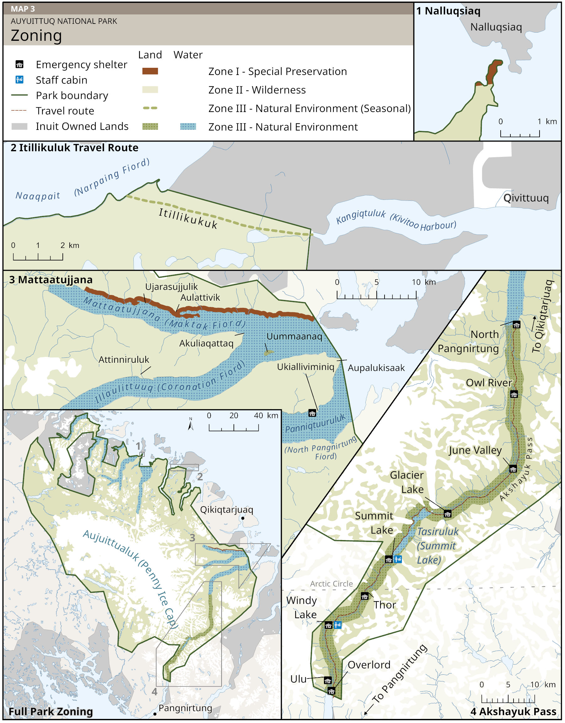
Map 3: Zoning in Auyuittuq National Park — Text description
The map shows zoning in Auyuittuq National Park. It contains one frame, titled Full Park Zoning, showing the whole park plus four insets, titled 1 Nalluqsiaq, 2 Itillikuluk Travel Route, 3 Mattaatujjana, and 4 Akshayuk Pass. All parts of the map are oriented north-up.
Full park zoning
The full park map shows Auyuittuq National Park stretching between Cumberland Sound in the southwest and Qikiqtaaluup Ikinga (Davis Strait) in the northeast. The park area is shown in light green and includes shaded mountains, glaciers, and waterways. The community of Qikiqtarjuaq is about 25 km east of the park boundary and Pangnirtung is about 25 km to the south. Parcels of Inuit Owned Land are shown in grey. A 0-40 km scale bar appears at the top right.
Four areas are numbered and marked on this map within the park:
- 1 Nalluqsiaq is marked on the northern boundary of the park
- 2 Itillikuluk Travel Route is marked on the eastern boundary of the park
- 3 Mattaatujjana is marked on the southeastern boundary of the park
- 4 Akshayuk Pass is marked on the southern boundary of the park
1 Nalluqsiaq
The first inset shows a narrow peninsula south of Nalluqsiaq. The end of the narrow peninsula is shown in red while land to the south is shown in light green. Nalluqsiaq island is shown outside the park boundary. A 0-1 km scale bar appears at the bottom right.
2 Itillikuluk Travel Route
The second inset shows a dashed green line representing an east-west travel route between Naaqpait (Narpaing Fiord) and Kangiqtuluk in the Qivittuuq (Kivitoo) area. The route passes through land within the park, shown in light green. Just to the north of the route is the park boundary, with Inuit Owned Lands beyond. A 0-2 km scale bar appears at the bottom left.
3 Mattaatujjana
The third inset shows Mattaatujjana (Maktak Fiord), Illaulittuuq (Coronation Fiord), and the mouth of Panniqtuuruluk (North Pangnirtung Fiord). A narrow strip of land along the north shore of Mattaatujjana is shown in red. Fiords are shown in dark blue and land within the park is shown in light green. A 0-10 km scale bar is at the top right. Inuktitut placenames are labelled as follows:
- Ujarasujjulik and Aulattivik on the central north coast of Mattaatujjana
- Akuliaqattaq at the point of land between Mattaatujjana and Illaulittuuq
- Uummaanaq, a small island at the mouth of Illaulittuuq
- Attinniruluk on the central north coast of Illaulittuuq
- Aupalukisaak at the point of land between Illaulittuuq and Panniqtuuruluk
- Ukialliviminiq on east side of the north shore of Panniqtuuruluk, where an emergency shelter is shown
4 Akshayuk Pass
A fourth inset shows Akshayuk Pass. The Pass is a 2.7 km wide, 100 km long corridor shown in dark green. It includes the Owl River Valley on the north side, Tasiruluk (Summit Lake) near the center, and the Weasel River Valley in the south. A travel route through the length of the Pass is shown with a brown dashed line. Nine emergency shelters are in Akshayuk Pass, spaced about 10 km apart (from north to south): North Pangnirtung, Owl River, June Valley, Glacier Lake, Summit Lake, Thor, Windy Lake, Ulu, and Overlord. Staff cabins are at Summit Lake and Windy Lake. Arrows point in the directions of Pangnirtung to the southwest and Qikiqtarjuaq to the north. A 0-10 km scale bar appears at the bottom right.
Legend (explained in words):
- Red: Zone I – Special Preservation
- Light green: Zone II – Wilderness
- Dark green: Zone III – Natural Environment (land)
- Dark blue: Zone III – Natural Environment (water)
- Grey: Inuit Owned Land
- Thick dark green line: park boundary
- Dashed brown line: travel route
- Cabin icon: emergency shelter
- Cabin and person icon: staff cabin
7.2 Area of Special Importance to Inuit
The Baffin IIBA (Article 8.1.12) requires that this management plan include specific measures to prohibit or restrict visitor access to any Areas of Special Importance to Inuit, either on a temporary or permanent basis.
The Inuit of Qikiqtarjuaq have identified Mattaatujjana (Maktak Fiord) and Illaulittuuq (Coronation Fiord) as an Area of Special Importance to Inuit (Map 4) for traditional activities in late summer, including narwhal harvesting, berry picking, and spending time at family cabins. Access to these two fiords is prohibited from August 25 until freeze-up each year to prevent disturbance to Inuit during this time. Parks Canada will work with the school administration in Qikiqtarjuaq to facilitate access to the north shore of Mattaatujjana for cultural activities undertaken there as part of the annual teacher orientation.
Map 4: Area of Special Importance to Inuit
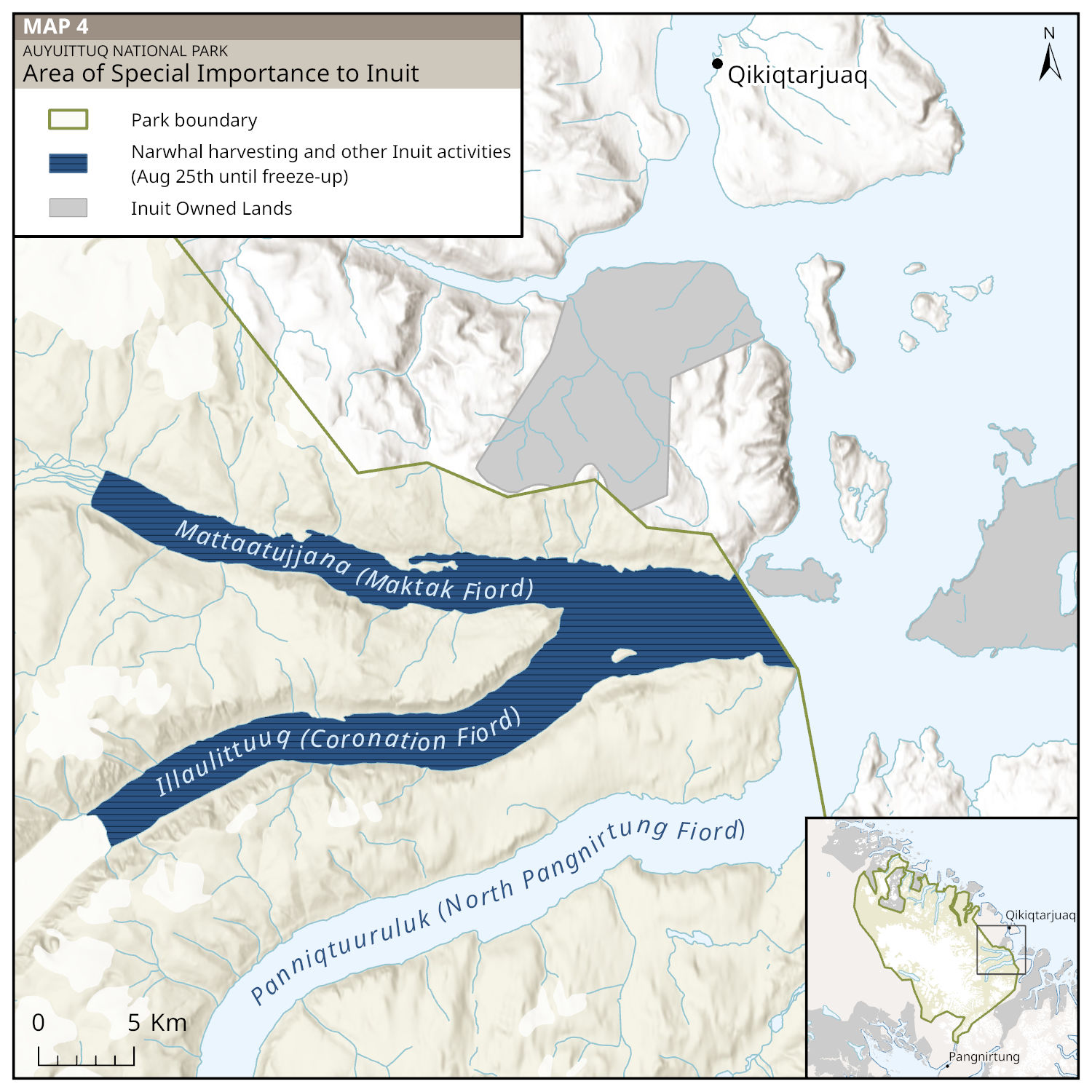
Map 4: Area of Special Importance to Inuit — Text description
This map shows an Area of Special Importance to Inuit in the southeastern part of Auyuittuq National Park. The park is shown in light green and includes shaded mountains, glaciers, and waterways. The map depicts three fiords within the park. Dark blue with white bars on the waters of Mattaatujjana (Maktak Fiord) and Illaulittuuq (Coronation Fiord) show a visitor closure for narwhal harvesting and other Inuit cultural activities from August 25 to freeze-up. Panniqtuuruluk (North Pangnirtung Fiord) is shown in light blue.
The community of Qikiqtarjuaq is about 25 km northeast of the park boundary. Parcels of Inuit Owned Lands around the park are shaded in grey. A scale bar (0-5 km) appears at the bottom left.
The map has a north-up orientation. A small inset at the bottom right locates the map area within the southeast coast of Auyuittuq National Park.
Legend (explained in words)
- Green: park boundary
- Dark blue with white bars: narwhal harvesting and other Inuit cultural activities (August 25 until freeze-up)
- Grey: Inuit Owned Land
Other visitor restrictions and closures
Article 8.1.10 of the Baffin IIBA indicates that Parks Canada may identify areas of the park that visitors can only enter if accompanied by a valid business license holder who is familiar with the area.
Motorized access in Zone III areas of the Northern Fiords, from Kangiqtullualuk (Okoa Bay) to Sarvalik (Confederation Fiord), requires that visitors travel with a Nunavut Inuk (Map 5). Inuit regularly travel to this part of the park for fishing, hunting, camping, berry picking, and other activities throughout the year. This remote but scenic area has had few visitors in the past, but travel here can provide opportunities for visitor appreciation and enjoyment of beautiful Arctic landscapes for those who are well prepared, have time for extended travel, and follow safe practices. Requiring visitors to travel with an Inuk enrolled under the Nunavut Agreement for motorized access supports economic opportunities for Inuit and encourages respectful travel within the Northern Fiords.
Article 8.1.8 of the Baffin IIBA indicates that Parks Canada may restrict or prohibit visitor access in one or more areas of the park, during one or more times of the year, for public safety reasons.
A polar bear denning season closure is in place for the Northern Fiords, from Kangiqtullualuk (Okoa Bay) to Sarvalik (Confederation Fiord) (Map 5). Polar bear activity is high in spring, when females and their cubs leave denning sites and hunt on the sea ice. A visitor closure is in place from March 1 to May 31 annually to support visitor safety and to reduce disturbances to polar bears during this important period.
Map 5: Other visitor restrictions and closures
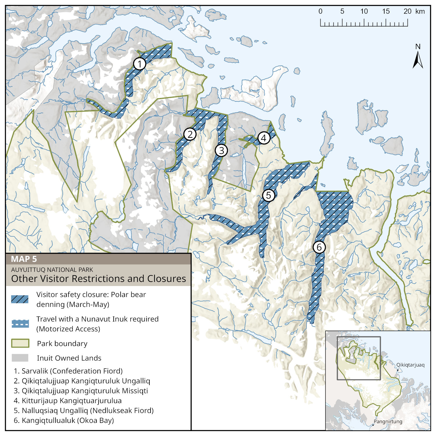
Map 5: Other visitor restrictions and closures — Text description
This map shows the visitor restrictions and closures in the Northern Fiords of Auyuittuq National Park, between Sarvalik (Confederation Fiord) and Kangiqtullualuk (Okoa Bay).
Six fiords have black cross-hatching to show that they are closed to visitors during polar bear denning between March 1 and May 31. The same six fiords also have white dashes to show that visitors must travel with a Nunavut Agreement beneficiary during any motorized travel. The legend lists these fiords by their Inuktitut and official names:
- Sarvalik – Confederation Fiord
- Qikiqtalujjuap Kangiqturuluk Ungalliq
- Qikiqtalujjuaq Kangiqturuluk Missiqti
- Kitturijaup Kangiqtuarjurulua
- Nalluqsiaq Ungalliq – Nedlukseak Fiord
- Kangiqtullualuk – Okoa Bay
The map has a north-up orientation. A scale bar (0-20 km) appears at the top right. A small inset at the bottom right locates the Northern Fiords area along the north coast of Auyuittuq National Park.
Legend (explained in words)
- Blue with black hatching: visitor safety closure – polar bear denning (March-May)
- Blue with white dashes: travel with a Nunavut Agreement beneficiary is required (motorized access)
- Green: park boundary
- Grey: Inuit Owned Land
8.0 Akshayuk Pass Management Area
The Akshayuk Pass route crosses the Cumberland Peninsula through a broad valley bordered by majestic mountain peaks. For many years this natural corridor has connected people living in nunaliit and, more recently, the communities of Pangnirtung and Qikiqtarjuaq. Its namesake, Akshayuk, was a hunter and whaler at Qikiqtat (Kekerten), who travelled through the pass around 1900, at a time when Inuit did not commonly use this route across the Cumberland Peninsula. More people began using the route, including Akshayuk’s stepson, Etuangat Akshayuk, a hunter and experienced traveller who often went this way by dog team. Following the route he had learned from his stepfather, he brought Inuit from surrounding areas to Pangnirtung for medical care. Etuangat Akshayuk was awarded the Order of Canada in 1995. Inuit continue to use the Pass, primarily for winter and spring travel between communities.
This 98 km route draws nearly all of Auyuittuq National Park’s visitors, most of whom come to hike, ski, or climb. Inuit outfitters provide transport to the endpoints at Panniqtuuruluk (North Pangnirtung Fiord) and Panniqtuup Kangiqtunga (Pangnirtung Fiord). Though unmarked, the route runs parallel to braided rivers and through valley terrain. Nine emergency shelters and outhouses are spaced approximately 10 km apart, and emergency caches are located beside major water crossings. Traversing the Pass is a truly world-class offer to travel a traditional route through a series of spectacular Arctic ecosystems, from fiord coastline and lush tundra to glaciers and rocky highlands. Akshayuk Pass has and continues to be an area that also attracts some scientific research, primarily focusing on glaciers and geology.
Zone III designation in the Akshayuk Pass Management Area (Map 6) highlights the area’s opportunities for low-impact recreation, with basic facilities to support public safety. Visitors typically undertake multi-day trips in the Pass, either choosing to travel self-supported or join a guided group. Since 2014, a Pangnirtung-based Inuit outfitter has run two seasonal day trip offers in partnership with Parks Canada, making travel to the park accessible for more people.
Climate change has resulted in increased travel hazards in Akshayuk Pass, particularly due to more variable and extreme weather. Shifting timing of freeze-thaw cycles for sea ice, erosion and rockfalls, flooding, accelerated glacier melt, and land instability have impacted the route in recent years.
Akshayuk Pass Management Area is expected to remain the primary corridor for park use into the future, and the objectives below address management issues related to this unique part of Auyuittuq.
Objective 1
Information and resources to support safe, compliant travel through Akshayuk Pass are available to all park users.
- 1.1: Monitoring and mitigation measures are developed, using Inuit Qaujimajatuqangit and Western science, to address evolving landscape changes in Akshayuk Pass
- 1.2: Existing emergency shelters, outhouses, and staff cabins are monitored for impacts from climate change and, whenever possible, maintained in the same or better condition as reported in the 2019 State of the Park Assessment
- 1.3: Through Parks Canada’s strategic engagement with regional air carriers as well as other government departments, all transiting aircraft comply with the Canada National Park Act and Transport Canada safety regulations
Objective 2
Akshayuk Pass provides memorable experiences and opportunities to learn about the route’s Inuit heritage.
- 2.1: The Inuit heritage of Akshayuk Pass, including its history and the significance of traditional placenames, are highlighted through Parks Canada materials
- 2.2: Seasonal day trip opportunities to this popular part of the park continue to be offered and promoted
- 2.3: Outfitters support visitor and staff access to the Pass, and Parks Canada continues to foster relationships with these service providers
Map 6: Akshayuk Pass Management Area
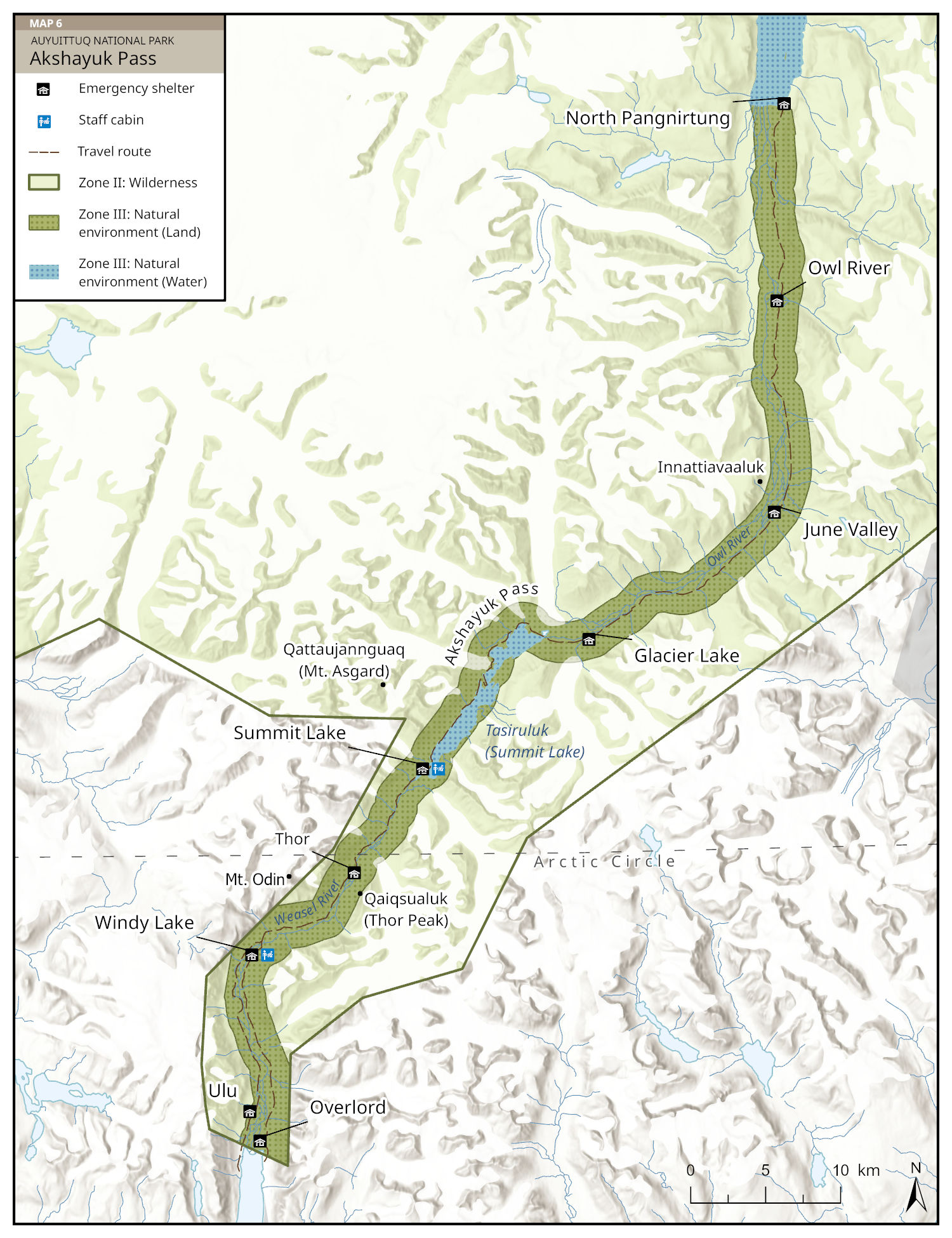
Map 6: Akshayuk Pass Management Area — Text description
This map shows Akshayuk Pass in the southern region of Auyuittuq National Park. The Pass is a 2.7 km wide, 100 km long corridor shown in dark green. It includes the Owl River Valley on the north side, Tasiruluk (Summit Lake) near the center, and the Weasel River Valley in the south. A travel route through the length of the Pass is shown with a brown dashed line.
Nine emergency shelters are in Akshayuk Pass, spaced about 10 km apart (from north to south): North Pangnirtung, Owl River, June Valley, Glacier Lake, Summit Lake, Thor, Windy Lake, Ulu, and Overlord. Staff cabins are at Summit Lake and Windy Lake. Labels are included for three distinct mountain peaks nearby (from north to south): Innattiavaaluk, Qattaujannguaq (Mt. Asgard), and Qaiqsualuk (Thor Peak).
Other areas within the park boundary are shown in light green (land) and dark blue (waterways). The map includes shaded mountains, glaciers, and waterways. The Arctic Circle is shown as a dashed line across the bottom of the map, just north of Thor shelter.
The map has a north-up orientation. A scale bar (0–10 km) appears at the bottom right.
Legend (explained in words)
- Cabin symbol: emergency shelter
- Cabin with person symbol: staff cabin
- Dashed brown line: travel route
- Light green: Zone II – Wilderness
- Dark green: Zone III – Natural Environment (land)
- Dark blue: Zone III – Natural Environment (aquatic)
9.0 Summary of the strategic environmental assessment
All national park management plans are assessed through a strategic environmental assessment to determine potential for cumulative effects from management actions as well as other factors. This understanding contributes to evidence-based decision-making that supports ecological integrity being maintained or restored over the life of the plan.
The Park Planning Team and Joint Park Planning and Management Committee discussed considerations for the strategic environmental assessment in 2024. Consultations with organizations in Pangnirtung and Qikiqtarjuaq during the same year highlighted community perspectives about valued components (the most important aspects of the environment in the park) and different stressors. Additional input from routine meetings as well as community member discussions with Parks Canada staff provided further context for the assessment process.
Impacts raised during discussions and consultations included climate change, activities and developments outside the park boundary, and marine vessels in and around the park’s fiords. Inuit identified several valued components within Auyuittuq National Park, such as Arctic wildlife (including fish, birds, and caribou) as well as Inuit traditional uses like travel and harvesting.
Climate change is expected to be the primary driver of impacts in the park over the next 10 years. Preparedness and responsiveness to climate factors will be key in the assessment of projects and activities within the park, and a precautionary approach will be taken for valued components already impacted by climate change.
Management plan targets aim to improve understanding of changes to valued components, including through continued ecological integrity monitoring, projects led by Inuit Knowledge focused working groups to address Inuit priorities, and considering both Inuit Qaujimajatuqangit and Western science data. Based on the strategic environmental assessment, there are no significant negative environmental effects anticipated from the implementation of this plan. All projects in the park are subject to assessment, either under the Nunavut Planning and Project Assessment Act or through Parks Canada's Impact Assessment process.
Related links
- ᑎᑎᕋᕐᑕᐅᒋᐊᙵᕐᑐᑦ ᑭᒃᑯᑐᐃᓐᓇᕐᓄᑦ ᑐᑭᓯᖃᑎᒌᒍᑎᑦᓴᑦ ᐅᓂᒃᑳᖑᔭᕆᐊᓖᑦ 2026
- Auyuittuq National Park management plan 2010
- Annual management plan implementation update 2021-2022
- Annual management plan implementation update 2019-2020
- Annual management plan implementation update 2018
- ᐊᐅᔪᐃᑦᑐᖅ ᑲᓇᑕᒥ ᒥᕐᖑᐃᓯᕐᕕᒃ ᐊᐅᓚᑎᓂᕐᒧᑦ ᐸᕐᓇᐅᑎᑦ 2010-ᒧᑦ
- ᐊᕐᕌᒍᑕᒫᑦ ᐊᐅᓚᑦᑎᓂᕐᒧᑦ ᐸᕐᓇᐅᑦ ᐊᑐᓕᖅᑎᑕᐅᓂᖓᓄ ᑐᑭᓯᒋᐊᕈᑏᑦ 2021-2022
- ᐊᕐᕌᒍᑕᒫᖅᓯᐅᑦ ᐊᐅᓚᑎᓂᕐᒧᑦ ᐸᕐᓇᐅᑎ ᐊᑐᓕᖅᑎᑕᐅᓂᖏᑦ ᖃᓄᐃᓕᖓᓂᖏᑦ 2019-2020-ᒧᑦ
- ᐊᕐᕌᒍᑕᒫᖅᓯᐅᑦ ᐊᐅᓚᑎᓂᕐᒧᑦ ᐸᕐᓇᐅᑎ 2018-ᒧᑦ
- Date modified :