
2026 Prescribed fires
Prince Albert National Park
Fire is a natural part of many ecosystems and plays an important role in the creation of habitat for many plants, animals, and insects. Some ecosystems are fire-adapted – meaning they have evolved with fire. Some of the plant species in these ecosystems require fire for reproduction, growth, and to stay healthy. Fire is a natural process that helps to renew and recycle many types of Canadian ecosystems including the boreal forest and prairie grasslands.
Wildland fire management has been a Parks Canada responsibility since the creation of the first national park in Canada in 1887. At that time, the focus was on the suppression of wildfire to
protect the public and natural resources. Parks Canada recognises the impact of the legacy of fire suppression including the exclusion of Indigenous cultural fire use. We are working to restore the role of fire and of Indigenous fire practitioners on lands administered by Parks Canada.
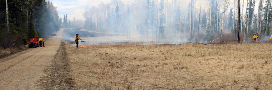
Parks Canada uses a variety of tools and strategies, including prescribed fires, forest thinning, and the creation of community fire guards, to reduce the impacts of wildfire and protect the public, communities, and infrastructure.
Prescribed fires will only proceed if the specific, pre-determined conditions are met.
Waskesiu Community Fuel Break
Date: late April to early May
Size: 40 ha.
Location: South of the Waskesiu townsite
Additional details: The Waskesiu Community Fuel Break Prescribed Fire burns off highly flammable dead grass and creates a meadow or ‘green belt’ south of the townsite of Waskesiu. This meadow helps slow approaching wildfires and gives valuable time to responders and the community if a wildfire approaches. This prescribed fire typically takes half a day to complete.

Map : townsite of Waskesiu in Prince Albert National Park with the Waskesiu Community Fuel Break — Text version
This map shows the townsite of Waskesiu in Prince Albert National Park with the Waskesiu Community Fuel Break. The map contains a legend and an inset map of Prince Albert National Park that marks the location of Waskesiu within the park. It also shows the 0 to 1 scale of the map in the bottom left corner. The map has the streets in Waskesiu as well as Highways 263 and 264. The community fuel break surrounds the townsite to the north, east and south with Lake Waskesiu to the west. The prescribed fire boundary is marked in the area south of the Waskesiu townsite.Paskwâw Mostos Prescribed Fire
Date: mid-April to early May
Sub-units and size: Amyot Trail (1,340 ha.)
Selected Meadows (up to 40 ha.)
Location: West side of Prince Albert National Park
Additional details: The Paskwâw Mostos Prescribed Fire Plan reintroduces fire to the ecosystem on the west side of Prince Albert National Park. Prescribed fire kick-starts ecosystem regeneration by providing ideal growing conditions for sun-loving plants. These plants will sprout soon after the fire is extinguished and animals will return to the area to feed on the nutritious new growth, including the Sturgeon River Plains Bison herd. These prescribed fires will take 2 to 3 days to complete.
For more information, please contact feu-princealbert-fire@pc.gc.ca or call 306-663-4522.
- Date modified :